

Dangerous Weather Percolates Over Nation's Midsection
Dangerous weather will rumble across the nation’s midsection to finish up a busy first few days to the work week. An intense tornado or two, damaging wind gusts, and very large hail will accompany the most intense activity through tonight.
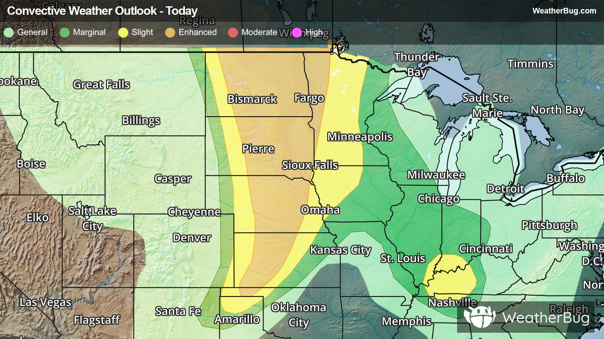
A Tornado Watch has been issued for western and central North Dakota and central South Dakota. This includes Bismarck and Minot, N.D., and Pierre, S.D.
Severe Thunderstorm Watches are in effect from northeastern New Mexico and the Texas and Oklahoma panhandles to eastern Colorado, and western and central Kansas into far south-central Nebraska. Trinidad, Col., McCook, Neb., and Russell, Salina, Goodland, and Garden City, Kan., are included in the watch.
A potent cold front is marching across much of the Dakotas, western Minnesota, Nebraska, western Iowa and parts of Kansas late this afternoon, with thunderstorms developing along and ahead of it already. This activity will intensify and dart farther east, organizing into lines or clusters with time overnight. Potentially destructive thunderstorms may impact much of Nebraska and the Dakotas into Minnesota and possibly, far western Wisconsin shortly prior to daybreak on Wednesday.
Farther south, thunderstorms are developing along a dryline from near the New Mexico and Texas border to western Kansas. Similar to their northern neighbor, thunderstorms will likely merge into clusters or lines while accelerating east and even southeastward in some instances through tonight.
The government’s Storm Prediction Center has issued an Enhanced Risk from the U.S. and Canada border in North Dakota and northwestern Minnesota to the Oklahoma panhandle. At first, particularly if thunderstorms can remain ahead of a line or cluster, there would be a risk for an intense tornado or two. Very large, destructive hail exceeding baseball size, and a few significant gusts up to 85 mph will be possible; widespread damaging wind is likely.
Grand Forks and Fargo, N.D., Sioux Falls and Pierre, S.D., Valentine, Neb., and Garden City and Liberal, Kan., are included in the Enhanced Risk. The Twin Cities, Omaha and Lincoln, Neb., and Colby, Kan., need to keep a watchful eye to the sky for threatening weather also.
Meanwhile, a couple of thunderstorm complexes could lead to severe weather headaches in the Ohio and Tennessee valleys to the Deep South tonight. Brief, damaging wind gusts and isolated large hail will be the main risks, although an isolated tornado or two cannot be ruled out. Nashville, Bowling Green, Ky., and Indianapolis may have a big storm encounter.
Soaking rain from repetitive thunderstorms has packed locally very heavy 3 to 5-inch totals across parts of central and eastern Kentucky. One to 3 inches could fall in a short time with new activity, particularly from Illinois and Indiana to Tennessee. This may lead to additional poor drainage, urban flooding or excess runoff that will overwhelm rivers, streams, creeks, and storm drains. Flood Watches are in effect from far southeastern Illinois and southern Indiana to much of Kentucky. If you approach a road covered in water, remember to, “Turn Around, Don’t Drown!”
Make sure to know the difference between a watch and a warning should they be issued. A "watch" means that conditions are favorable for severe weather to occur, and to be on alert for any rapidly changing conditions. A "warning" means that severe weather is imminent, and you should act fast to remain safe.
The best way to remain safe is to stay prepared and informed about your local weather. Have a severe weather kit packed with a battery-operated radio, water, and non-perishable food items. Also, check the WeatherBug app frequently for any updates on today's severe weather. Remember, "When Thunder Roars, Go Indoors!"